

| Navigate By... | ...Back to All Ordinances |
|---|---|
| Related Area: | | Council | | Council | | Elections | |
| Related Elkins Municipal Code (EMC): | |
| Related Year: | 2022 | |
Ordinance #: 2022-02
AN ORDINANCE REDISTRICTING CITY WARDS
WHEREAS, cities have an obligation and a responsibility to insure that wards are of substantially equal population; and
WHEREAS, a demographic analysis of the City’s wards has been conducted, and a recommendation made that redistricting be undertaken, and
WHEREAS, Arkansas law vests city councils with apportionment and redistricting authority, and
WHEREAS, it is the desire of the City Council that new ward boundaries be established.
NOW THEREFORE, BE IT ORDAINED BY THE CITY COUNCIL OF THE CITY OF ELKINS, ARKANSAS:
SECTION 1. The ward redistricting plan, consisting of the map attached hereto and made a part hereof, is hereby adopted, and shall with serve hereafter as the official ward map for the City of Elkins.
SECTION 2. All previous ward maps and descriptions are hereby repealed,
SECTION 3. A certified copy of said map shall be submitted to the Washington County Election Commission, and filed in the Office of the Washington County Clerk.
PASSED AND APPROVED THIS
17th DAY OF February 2022
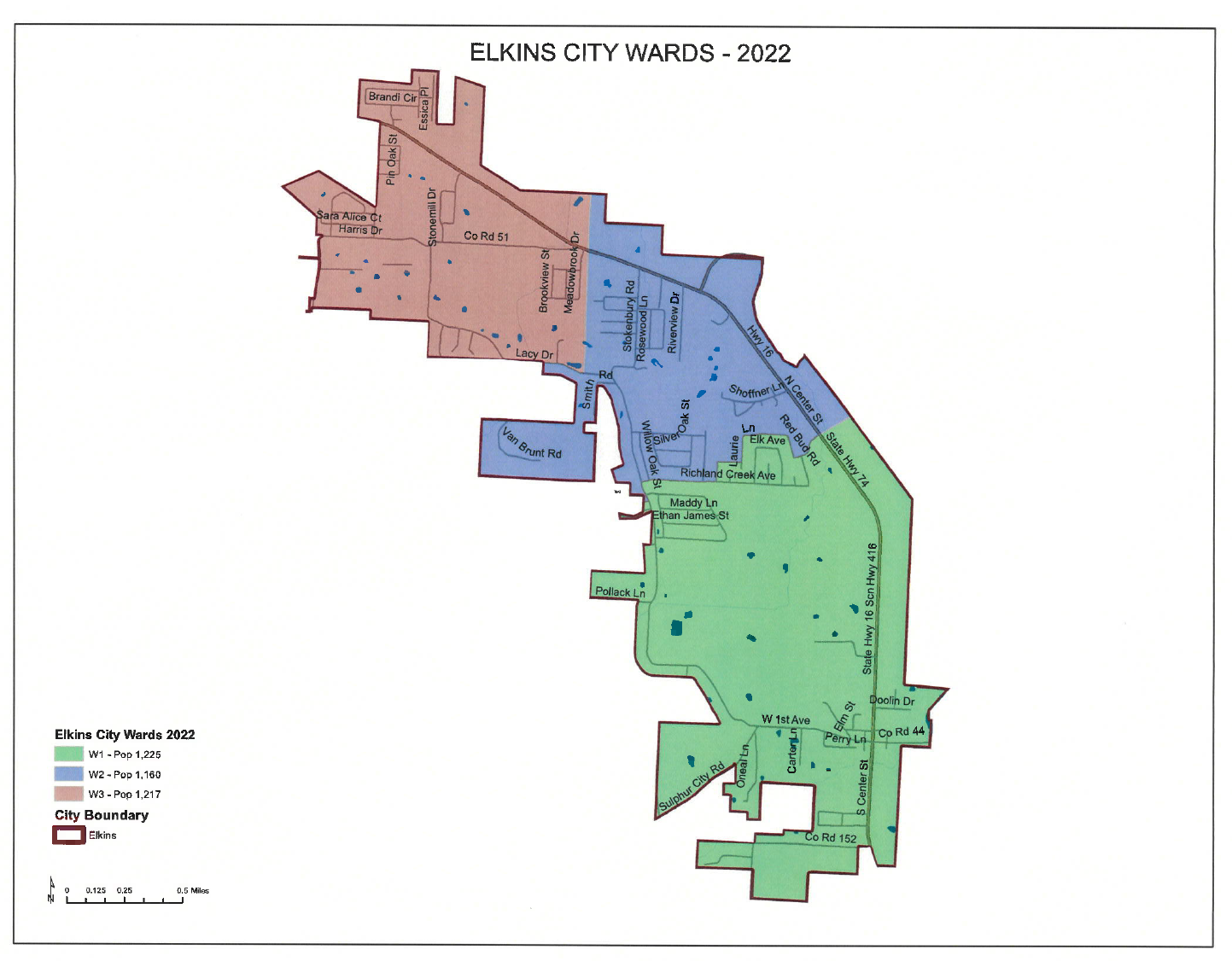
City of Elkins 2022 Ward Boundaries
Ward 1- Beginning at the intersection of the city limit line and Bobbie Road; thence easterly along Bobbie to Stokenbury Road; thence northerly along Stokenbury to Richland Creek Avenue; thence easterly along Richland Creek to Frisco Track Trace; thence north along Frisco Track to Thaliel Street; thence east along Thaliel to Laurie Lane; thence north along Laurie to Stowers Avenue; thence easterly along Stowers to Redbud Road; thence southerly along Redbud to Oakwoods Drive; thence northeasterly along Oakwoods to Hwy. 16; thence due northeast from the intersection of Oakwoods and Hwy. 16 to the city limit line; thence in a generally clockwise direction along the city limit to the P.O.B. Population – 1,225
Ward 2 – Beginning at the intersection of Lacy Drive and the city limit line; thence in a generally southerly and counterclockwise direction along the city limit line to Bobbie Road; thence easterly along Bobbie to Stokenbury Road; thence northerly along Stokenbury to Richland Creek Avenue; thence easterly along Richland Creek to Frisco Track Trace; thence north along Frisco Track to Thaliel Street; thence east along Thaliel to Laurie Lane; thence north along Laurie to Stowers Avenue; thence easterly along Stowers to Redbud Road; thence southerly along Redbud to Oakwoods Drive; thence northeasterly along Oakwoods to Hwy. 16; thence due northeast from the intersection of Oakwoods and Hwy. 16 to the city limit line; thence northwesterly along the city limit line to a point due north of the NE corner of Meadowbrook Subdivision; thence due south to the NE corner of Meadowbrook Subdivision; thence south along the east line of Meadowbrook Subdivision to the SE corner of said Subdivision; thence due south from SE corner Meadowbrook Subdivision to Lacy Drive; thence westerly along Lacy to the P.O.B. Population – 1,160
Ward 3 – Beginning at a point on Lacy Drive due south of the SE corner of Meadowbrook Subdivision; thence north to the SE corner of Meadowbrook Subdivision; thence north along the east line of Meadowbrook Subdivision to the NE corner of said Subdivision; thence due north to the city limit line; thence in a generally counterclockwise direction along the city limit line to Lacy Drive; thence easterly along Lacy to the P.O.B. Population – 1,217